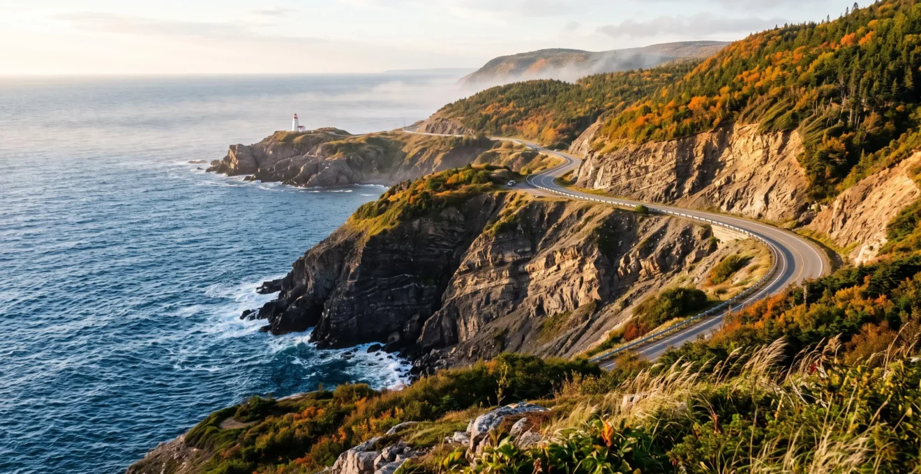
From the cliffs of Cape Breton to the red beaches of Prince Edward Island, Canada’s maritime landscapes offer very different experiences depending on the region you choose. On the Atlantic, scenic roads pass through fishing villages, run alongside lighthouses, and reveal bays where the tides transform the shoreline. On the Pacific, rainforests meet the ocean at the foot of steep mountains.
For a three-day coastal stay, the Cabot Trail, in Nova Scotia, is an attractive option thanks to its road loop and its many viewpoints. With a week or more, the Gaspé Peninsula lets you multiply the stops between sea, cliffs, and villages. Prince Edward Island is particularly suited to travelers who favor beaches, dunes, and a more relaxed pace.
The choice also depends on the season, the distances, the tides, and the type of lodging you are looking for. A successful itinerary is not about piling up kilometers: it leaves enough time to walk, watch the light, and enjoy the coastline without rushing.
The essentials for discovering Canada’s coasts
- For three days: favor a coherent section of the Cabot Trail and allow time for the panoramas.
- For a week or more: explore the Gaspé Peninsula or combine several nearby maritime regions.
- For beaches and quiet: consider Prince Edward Island or a secondary shoreline, paying particular attention to the tides and the weather.
- Why are the Atlantic and Pacific landscapes so different?
- How do you organize a three-day coastal itinerary on the Cabot Trail?
- Gaspé Peninsula or Prince Edward Island: which destination should you choose to see the sea?
- What dangers should you watch for when exploring the beaches of the Bay of Fundy?
- When should you photograph coastal cliffs to take advantage of beautiful light?
- Forest or lakeside: which setting should you choose for a quiet stay?
- How do you organize a first kayak outing on a Canadian lake?
- Where can you find a restorative setting in Canada for a getaway far from the hustle and bustle?
Why are the Atlantic and Pacific landscapes so different?
Canada’s Atlantic and Pacific coasts have different landscapes because of their geological history, their terrain, and their climatic conditions. The Atlantic combines beaches, rocky headlands, cliffs, and coastal villages, while the Pacific stands out notably for its coastal mountains, deep inlets, and temperate rainforests.
On the Atlantic side, marine erosion shapes rocks of differing resistance. The red sedimentary formations of Prince Edward Island contrast with the rocky terrain of Cape Breton or the spectacular cliffs of the Gaspé. This diversity prevents the entire East Coast from being reduced to a single type of landscape.
The Pacific side has a different story. Plate tectonics, movements of the earth’s crust, and glacial erosion helped form a rugged mountainous terrain. Valleys flooded by the sea make up some of British Columbia’s fjords. On the west coast of Vancouver Island, wild beaches meet dense vegetation directly.
In the Pacific Rim region, annual precipitation reaches approximately three meters, according to the presentation of the temperate rainforests of Pacific Rim by Parks Canada. This value describes a particularly wet coastal environment, not the whole of British Columbia.
The cultural experience also changes. On the Atlantic, fishing villages, Acadian and Gaelic traditions, and small coastal roads fit easily into a car trip. On the Pacific, the long beaches, old-growth forests, and the possible sighting of whales or orcas appeal more to wilderness lovers, with no guarantee of encountering wildlife.
| Criterion | Atlantic | Pacific |
|---|---|---|
| Landscapes sought | Cliffs, beaches, lighthouses, and maritime villages | Coastal mountains, wet forests, and wild beaches |
| Type of stay | Road trip and cultural discoveries | Hiking, nature, and marine excursions |
| Mobility | Many panoramas accessible by car | Some areas require walking, a boat, or extra logistics |
| Season | May to October for many activities, depending on the region | Climate often relatively mild on the southwest coast, but frequent rain |
In fall, Atlantic disturbances and the remnants of tropical storms can alter travel conditions. On the Pacific, rain and foggy spells call for suitable clothing, even when temperatures remain moderate.
Travelers who want to link several viewpoints without multiplying sea crossings will find on the Cabot Trail an accessible and varied Atlantic itinerary.
How do you organize a three-day coastal itinerary on the Cabot Trail?
To discover the Cabot Trail in three days, it is better to divide the stages among the heights of Cape Breton Highlands National Park, the panoramas of the west coast, and the villages of the east coast. This organization limits overly packed days and leaves a margin for hikes, photo stops, and weather changes.
The Cabot Trail forms a loop of nearly 300 kilometers around the north of Cape Breton Island. About 106 kilometers cross the national park, according to the Cabot Trail access information published by Parks Canada.
A three-day route can start near Chéticamp, on the west coast, then reach the Ingonish area via the highlands. The exact order depends on the starting point and the direction of travel.
- Day 1 — The highlands: reach Chéticamp, discover the first viewpoints, then devote time to the mountain landscapes of the national park. Plan a short walk when conditions allow.
- Day 2 — The western panoramas: explore the headlands and viewpoints overlooking the Gulf of St. Lawrence. Organize the stops so as to enjoy the late-day light before reaching your lodging.
- Day 3 — The east coast and its villages: discover the Ingonish area, its beaches and maritime landscapes, then finish the loop or head back south.
This example spreads out the experiences rather than three strictly independent road sections. Depending on the lodging chosen, it may require going back over a stretch of the Cabot Trail. A traveler wishing to avoid such backtracking can favor a continuous loop, even if it means changing the order of the visits.
The clockwise direction notably lets you approach the park via Chéticamp, while the counterclockwise direction leads toward Ingonish. The latter may put the vehicle more on the outer side on some scenic stretches, but this is not a constant advantage: stopping opportunities, visibility, and safety take priority over the driver’s position.
Nearly 300 km
Length of the Cabot Trail loop, of which about 106 km are within Cape Breton Highlands National Park.
Parks Canada, official park access information.
In July, in August, and during the fall color season, booking lodging early reduces the risk of having to make long detours. Filling up with fuel before the isolated sections and bringing something to drink and eat avoids depending on a distant or closed business.
Fog can hide the main viewpoints. In that case, favor villages, small sheltered coves, and accessible interpretation centers. Local cultural activities, notably around Mi’kmaq and Gaelic traditions, are interesting alternatives, subject to opening hours.
The success of the route depends less on the number of kilometers driven than on the time actually devoted to the landscapes. For a longer trip, the Gaspé Peninsula and Prince Edward Island offer two other ways to discover the Canadian Atlantic.
Gaspé Peninsula or Prince Edward Island: which destination should you choose to see the sea?
The Gaspé Peninsula suits travelers looking for big cliffs, mountainous terrain, and a spectacular maritime itinerary. Prince Edward Island will appeal more to those who favor long beaches, dunes, and accessible coastal landscapes. The former favors an adventurous road trip; the latter allows a generally more relaxed stay.
In the Gaspé, Route 132 runs along much of the coastline and links emblematic destinations such as Percé, the Forillon area, and several villages dominated by the Appalachians. Rocky headlands, lighthouses, and coves follow one another, but the distances between the main sites require planning the stages.
At Percé, the emblematic rock and the surrounding cliffs give the landscape a monumental dimension. Farther north, the mountains sometimes seem to meet the Gulf of St. Lawrence directly. This variety justifies setting aside several days for travel and stops.
Prince Edward Island has a gentler terrain. Its red sandstone cliffs, dunes, and sand beaches form a particularly photogenic shoreline. The world of Anne of Green Gables adds a literary dimension to visits, notably in the Cavendish area.
| Criterion | Gaspé Peninsula | Prince Edward Island |
|---|---|---|
| Dominant landscapes | Cliffs, mountains, headlands, and lighthouses | Beaches, dunes, red cliffs, and farmland |
| Ideal pace | Road trip with several stages | Stay built around a few lodging bases |
| Activities | Hiking, marine observation, and photography | Beach walks, cycling, and cultural discoveries |
| Duration to consider | A week or more for an extensive exploration | A few days for a selection of sites |
| Atmosphere | Wide-open spaces and impressive terrain | Seaside atmosphere and a quieter pace |
Crowds generally increase in July and August in the major tourist areas. June and September can offer more tranquility, with reservations about swimming temperatures and the seasonal opening of services. Whale-watching excursions in the Gaspé depend on the operators, the species present, and the weather.
Combining the two destinations remains possible for a sufficiently long trip. From the Gaspé, heading toward New Brunswick and then Prince Edward Island lets you cross the Confederation Bridge. A ferry link between Nova Scotia and the island can also be part of a larger circuit, subject to its schedules and seasonal operation.
Whatever the destination, the spectacle of the shoreline changes with the tide. In the Bay of Fundy, this variation even requires special precautions before going down to the beaches.
What dangers should you watch for when exploring the beaches of the Bay of Fundy?
In the Bay of Fundy, the main danger is the rising tide, which can cut off access to a beach or surround visitors on the tidal flats. Mudflats, unstable cliffs, currents, and cold water temperatures are other risks. Any exploration should begin by checking local forecasts and the site’s guidelines.
The Bay of Fundy, between New Brunswick and Nova Scotia, is known for the largest tidal ranges in the world. At Fundy National Park, the difference between high tide and low tide can reach 12 meters; at the head of the bay, it can reach 16 meters. These maximums do not apply uniformly to every beach.
This phenomenon results notably from the resonance of the water’s movements and the shape of the bay. According to Parks Canada’s explanations of the Fundy tides, the average interval between a high tide and a low tide is about six hours and thirteen minutes.
At Hopewell Rocks, the rock formations can be admired from developed viewpoints or, during authorized periods, from the exposed seabed. An area accessible at low tide can quickly become impassable when the water rises.
Mudflats present an additional risk: some soft surfaces can cause people to get stuck. You should avoid venturing onto a muddy area that is unauthorized or unfamiliar. Narrow passages, caves, and rocky hollows are also dangerous if the water cuts off the exit.
Swimming calls for particular caution. Cold water can cause a rapid loss of physical abilities, and local currents can make it harder to return to shore. The existence of a beach does not mean it is suitable for swimming.
The five checks before going down onto the tidal flats
- Check the tide times for the area with the official services of Fisheries and Oceans Canada. Deliverable: note the time of the next high tide and that of the low tide.
- Verify the access periods authorized by the site’s operator. Deliverable: keep a confirmed visiting time window.
- Locate the main access and the way back. Deliverable: identify a safe exit point on site.
- Observe the condition of the terrain, the cliffs, and any restricted areas. Deliverable: define a route limited to authorized sectors.
- Set a cautious return time, in line with local guidelines. Deliverable: set an alarm and allow a sufficient margin before the water rises.
On the heights, staying away from cliff edges and keeping to marked trails limits the risk of falls and landslides. Coastal rocks can be weakened by erosion, even when the ground seems stable.
Careful preparation lets you appreciate these changing landscapes without taking unnecessary risks. It also makes photography easier, since the best coastal compositions often depend as much on the tides as on the light.
When should you photograph coastal cliffs to take advantage of beautiful light?
Canadian coastal cliffs are generally photographed at sunrise or sunset, when the raking light reveals rock volumes and textures. The orientation of the shoreline determines the best time, but tides, fog, and weather remain essential. Diffuse light can also produce superb images, particularly on the Atlantic.
A cliff facing east often benefits from interesting lighting in the morning, when the sun directly illuminates the rock. On the western coasts of Cape Breton, the end of the day can on the contrary reveal the terrain thanks to warmer, side-on light.
The photographer’s position matters as much as the general orientation of the coast. A curved bay, a headland, or a promontory can completely change the angle of the light. Before an outing, examining a map and identifying the direction of sunrise or sunset helps in choosing a viewpoint.
On the Atlantic, a light fog can soften contrasts and visually separate the different planes of the landscape. Clearings after rain sometimes bring out the colors of rocks and plants. In fall, the foliage on the heights of Cape Breton adds orange and red tones to compositions.
The length of the golden hour varies with latitude and season. At Canadian latitudes, the light transition is often more gradual than at low latitudes, notably around the long days of summer. In September, lower light can also enhance landscapes, with no guarantee of favorable weather.
The Bay of Fundy introduces another parameter: the tide. An arch, a sandbar, or a rock formation can change appearance entirely depending on the water level. Shooting times must therefore first respect the safe access windows.
- Give a sense of scale: include a lighthouse, a distant boat, or a walker on an authorized trail.
- Showcase the sky: place the horizon lower when the clouds are part of the composition.
- Reveal textures: prefer side lighting to distinguish rock relief.
- Make use of change: photograph clearings, banks of fog, and the movement of the water without getting dangerously close to cliffs.
A wide-angle lens conveys the breadth of a bay, while a longer focal length isolates successive headlands and distant boats. Using a tripod depends on the stability of the terrain and the site’s rules.
After several days devoted to scenic roads and viewpoints, choosing more sheltered lodging lets you slow the pace while still enjoying Canadian nature.
Forest or lakeside: which setting should you choose for a quiet stay?
For a quiet coastal stay, lodging in the forest or near a lake, at a reasonable distance from the ocean, often offers more calm than accommodation directly on the waterfront. The seaside remains preferable for watching the waves from the moment you wake up, but it is more exposed to wind, humidity, and sometimes tourist crowds.
Lodging located directly facing the ocean has an obvious appeal: changing light, the sound of the waves, and quick access to panoramas. Their price can, however, be higher in sought-after areas, particularly in high season. The proximity of a busy coastal road can also reduce the expected tranquility.
A few kilometers from the coast, a forest cabin or a small house near a lake offers a different rhythm. The landscapes are less open, but the trees sometimes protect from the wind and evenings can be quieter. This option suits travelers sensitive to weather conditions or wanting to alternate maritime visits with moments of rest.
| Criterion | Seaside | Forest or lakeside |
|---|---|---|
| View and atmosphere | Open horizon, waves, sea winds | Vegetation, calm water, and a sheltered atmosphere |
| Budget | Rates sometimes higher in sought-after spots | Potentially more economical options depending on location |
| Sound comfort | Waves, wind, and possible crowds | Relative calm, natural sounds, and wildlife |
| Access to panoramas | Often immediate | Travel to plan for |
| Seasonal constraints | Humidity, sea spray, and wind exposure | Insects, ground moisture, and sometimes seasonal access |
In Nova Scotia and Quebec, inland lake areas can serve as a stopover between two maritime stages. Fall is sometimes favorable for this type of stay, with an appealing forest atmosphere, even though temperatures and shorter days limit some water activities.
In early summer, mosquitoes and other insects can be particularly present near wet environments. A mosquito net, suitable clothing, and a check of the lodging’s equipment improve comfort. The length of summer days is also worth anticipating for travelers sensitive to light.
The chalets, shelters, and accommodations operated in national parks have limited capacity. It is better to check opening periods and reservations with the operators concerned rather than count on spontaneous availability.
A lake does not serve only as a refuge after several days by the ocean: it can also become a training ground for water activities before a possible exploration of the coast by kayak.
How do you organize a first kayak outing on a Canadian lake?
A first kayak outing on a Canadian lake should favor calm water, stable weather, and a short route close to shore. The ideal is to rent suitable equipment from a professional, wear a personal flotation device, and start by learning to steer, stop, and stabilize the craft before extending the distance.
A lake is an interesting learning environment before sea kayaking. The absence of tides on inland lakes simplifies preparation, even though wind, waves, local currents, and water temperature can still create dangerous situations.
To start, choosing a sheltered, little-used area makes it possible to reduce interactions with motorized craft. A rental center offering safety instructions and, ideally, a supervised introduction makes it easier to learn the basic techniques.
The first maneuvers consist of maintaining a stable posture, making symmetrical paddle strokes, slowing down, and turning without unbalancing the kayak. A first session of about an hour near the shore is an example of cautious progression, not a regulatory duration or a guarantee of mastery.
In Canada, non-motorized kayaks are subject to safety equipment requirements. According to Transport Canada’s rules for human-powered craft, these craft must carry certain equipment provided for by the applicable regulations.
The presence on board of an appropriate personal flotation device should not be confused with a general federal obligation to wear it at all times. Actually wearing it nevertheless remains a strongly recommended precaution. The other required equipment varies depending on the craft and the applicable regulatory exceptions.
Transport Canada also insists on the visibility of kayakers. Bright colors and accessible signaling devices make it easier for other water users to spot them. A tether or a device suited to the equipment can be useful in certain conditions, without being a general regulatory requirement.
Before leaving, check the wind forecast, the risk of thunderstorms, and the water temperature. Letting a trusted person know your route and expected return time adds extra safety. In case of sustained wind or a forecast thunderstorm, postponing the outing remains preferable.
After mastering the maneuvers near the shore, a small loop can be considered if conditions remain favorable. The distance must remain compatible with the beginner’s abilities. A sea outing then requires additional skills related to tides, currents, and navigation.
This activity can enrich a quiet stopover between two major coastal stages. It also reminds us that a successful stay in Canada can combine spectacular landscapes and moments of disconnecting, without systematically seeking out the busiest sites.
Key takeaways for favoring calm
- The best-known coastal destinations are not essential for discovering beautiful maritime landscapes: secondary areas often offer a more peaceful experience.
- A longer access route or a ferry link can reduce crowds, but requires planning lodging, supplies, and schedules.
- Alternating a few days of scenic discovery with a stopover in a secluded place helps you fully enjoy the trip without multiplying travel.
Where can you find a restorative setting in Canada for a getaway far from the hustle and bustle?
For a peaceful maritime getaway in Canada, the Magdalen Islands, certain areas of the north coast of New Brunswick, and the small coastal communities of Nova Scotia are interesting options. Calm nevertheless depends on the season and the location: favoring areas far from the main tourist hubs, outside the busiest periods, lets you better enjoy the landscape.
The Magdalen Islands, in Quebec, offer a special experience with their beaches, colorful cliffs, and vast maritime horizons. Their distance from the mainland is part of the destination’s charm, but requires organizing transportation, notably the sea crossing or the flight depending on the chosen itinerary.
Accessible beaches, back roads, and small villages favor a slow pace. However, the archipelago attracts many visitors in summer: a peaceful atmosphere therefore cannot be guaranteed everywhere, particularly in July and August.
On the north coast of New Brunswick, villages and lesser-known coastal areas let you discover another side of the Maritimes. The landscapes of the Gulf of St. Lawrence, local harbors, and Acadian heritage offer an experience more focused on everyday coastal life than on piling up grand panoramas.
In Nova Scotia, the small communities located away from the busiest stretches of the Cabot Trail are an alternative to the emblematic viewpoints. Coves, fishing harbors, and short coastal walks can be enough to structure a day.
To choose a truly restorative destination, several criteria deserve examination:
- Accessibility: a secondary road or a ferry can limit spontaneous trips, but require more advance planning.
- Crowds: September and, depending on the place, part of October can offer a calmer atmosphere than the heart of summer.
- Protected nature: proximity to natural areas encourages walks and observation of the shoreline, subject to access rules.
- Services: check shops, restaurants, lodging, and gas stations, notably in the off-season.
- Connectivity: plan for maps available offline when the cell network is uncertain.
A stay combining two or three days at a major scenic site and two days in a more secluded locality is one example of a possible balance. Travelers can thus enjoy the emblematic landscapes without having to change lodging every night.
In isolated areas, advance booking and suitable provisioning remain essential. The availability of ferries, shops, and activities should be checked before departure, especially in fall.
The best starting point is to choose a coast according to the time available, then settle on a lodging base and a few sites accessible without long days on the road. Such an organization leaves room for the unexpected, for spontaneous walks, and for discovering maritime landscapes at your own pace.
How much time should you allow to discover several coastal regions of Canada?
Three days let you discover a relatively concentrated region, such as a selection of sites on the Cabot Trail. A week offers more freedom to explore an extensive destination such as the Gaspé Peninsula. To combine several Maritime provinces, it is better to plan a longer stay and include travel times.
Can you admire Canadian maritime landscapes without long hikes?
Yes. The Cabot Trail, Route 132 in the Gaspé, and several coastal roads on Prince Edward Island offer panoramas accessible by car. Developed viewpoints let you enjoy the coastline without undertaking a demanding hike. The precise accessibility of each stop should nevertheless be checked.
Do you need to reserve a car to explore Canada’s coasts?
A car is generally the most flexible solution for linking several viewpoints and villages on the itineraries described. Organized excursions and local transportation may exist in certain areas, but their frequency, coverage, and seasonal availability should be confirmed before departure.
How do you adapt a Canadian coastal itinerary in case of bad weather?
It is best to keep a margin in the schedule and plan alternative activities: visiting villages, museums, interpretation centers, or short walks in authorized, sheltered areas. In case of strong winds, thunderstorms, heavy swell, or poor visibility, water activities and exposed trails should be reassessed.
What should you check before visiting an isolated beach in Canada?
You should check weather conditions, tide times where relevant, access restrictions, and the site operator’s guidelines. It is also important to identify the way back, take cell coverage into account, and avoid unstable cliffs, unfamiliar mudflats, and areas exposed to currents.